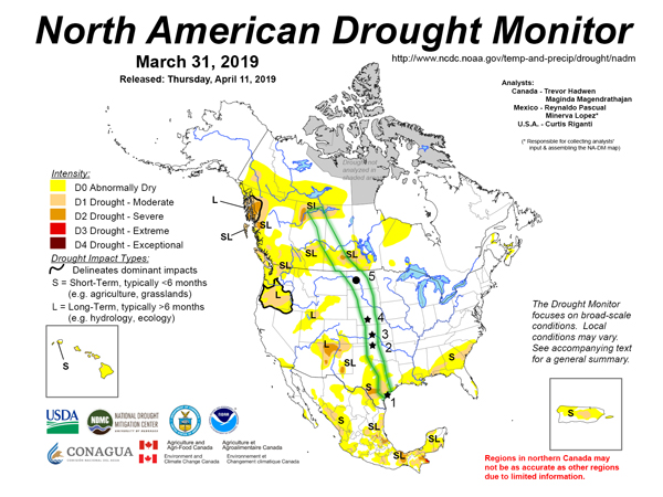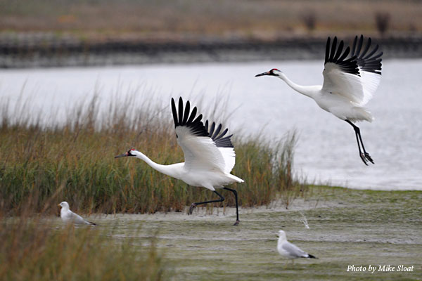
As the Aransas-Wood Buffalo population of Whooping Cranes makes their annual journey north, the Texas team is analyzing the drought conditions along the crane’s migration route. Below you will find a map illustrating the migration route overlaying the most recent available drought map.
This map, just like the migration of the Whooping Cranes, reminds us that the natural world interconnects across all borders. We must work collectively for the health of our shared environment. Check out our frequently asked questions to learn more about this complex issue:
What is the North America Drought Monitor?
• In their own words, “the North American Drought Monitor (NADM) is a cooperative effort between drought experts in Canada, Mexico and the United States to monitor drought across the continent on an ongoing basis… the North American Drought Monitor blends science and art. There is no one ‘correct’ way to measure drought. Drought indices are used to detect and measure droughts, but different indices measure drought in different ways, and no single index works under all circumstances (Heim, 2002). So the Drought Monitor concept was developed (jointly by the National Weather Service, the National Drought Mitigation Center and the US Department of Agriculture’s Joint Agricultural Weather Facility in the late 1990s) as a process that synthesizes multiple indices, outlooks and local impacts, into an assessment that best represents current drought conditions. The final outcome of each Drought Monitor is a consensus of federal, state and academic scientists.”
• View the most up-to-date North American Drought Monitor Map here. And, view the United States specific maps and explore interactive mapping illustrations here.
• The map you are viewing is a blend of science and art – combining the drought map of March 2019 with the Whooping Crane’s migration corridor and a few points of interest. We took artistic license in blending multiple map projections to create the most realistic and easy to understand visual learning tool as possible.
• Stars – The starred regions on the map indicate designated critical habitat areas numbered as follows:
Aransas National Wildlife Refuge in Texas
Salt Plains National Wildlife Refuge in Oklahoma
Quivira National Wildlife Refuge and Cheyenne Bottoms in Kansas
Central Platte River in Nebraska
• Circle – The single black circle on the map represents one of the most northern locations where recreational birders have viewed migrating Whooping Cranes with photo verification. At the time of publishing, the birds were viewed last at this location on April 12, This area currently is not under any drought conditions.
Why does drought matter?
• We are most likely to notice drought when it is in our own backyards. Many cities have drought regulations affecting practices, such as how often you’re allowed to water your lawn. However, drought often has sweeping effects across our natural landscape.
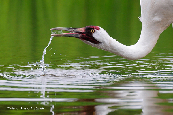
• In the Coastal Bend of south Texas, drought affects how much fresh water comes into our coastal ecosystem. The barrier islands off the coast create bays where fresh water from rivers blends with salt water from the Gulf of Mexico. Along the mainland coasts of the bays, we have marshes that need fresh water. During droughts, people usually take the same amount of water from the rivers as during normal conditions, so less fresh water is available on the natural landscape. This causes the marshes and bays to become more salty, leaving less water for Whooping Cranes to drink and harsher conditions for the aquatic animals they eat.
• As the cranes travel farther north along the migration route, they leave saltwater environments behind and enter areas of plains, prairies, and of course, wetlands. Wetlands are especially susceptible to drought conditions. Without enough water, Whooping Cranes may not have access to food resources or good places to roost. As a result, birds have to travel longer distances in their search for a nightly resting spot.
• In the breeding grounds of Wood Buffalo National Park in Canada, drought conditions in the wetland areas the Whooping Cranes favor for nest building can cause them to move outside their preferred territories and can even cause fewer nesting sites to be built.
Why monitor drought along the migration route for the Aransas-Wood Buffalo population of Whooping Cranes?
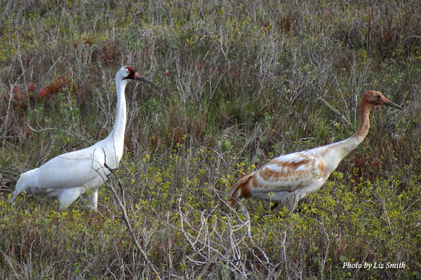
• Conditions for Whooping Cranes matter in their summer home at Wood Buffalo National Park in Canada, their winter home at Aransas National Wildlife Refuge in the United States and all along their migration route.
• Whooping Cranes spend up to 15 percent of their yearly cycle – about eight weeks – traveling along their migration route. The cranes do not fly at night and need a wetland to stop in each day, sometimes for multiple days. When droughts negatively affect those wetlands, it can affect the cranes as they migrate.
• Even if there is not a drought at Wood Buffalo National Park or Aransas, monitoring drought along the migration route can indicate what conditions the cranes are facing on their journey. Droughts can easily expand over time, so tracking where drought is headed can help us prepare for those conditions if they expand to the breeding or wintering grounds.
How can I help with drought conditions?
• While drought and “wet” cycles are normal and natural for many ecosystems – such as the Coastal Bend of Texas surrounding the Aransas National Wildlife Refuge – many drought conditions can be worsened by people.
• Reduce your water usage at home, school and work – no matter the time of year or current drought conditions. Reducing water usage can help reduce the impact of droughts. The EPA’s WaterSense guide is a great place to start with ideas on saving water.
• Support your local National Wildlife Refuge, State Park or other areas that prioritize habitat protection. Ensuring that these spaces have the funding and resources they need allows for drought mitigation and management when it matters the most. Not sure where to start? Find Your Park.
• Support your local land trusts who work to protect wildlife habitat, preserve freshwater resources and secure conservation easements. Locate a land trust near you.
