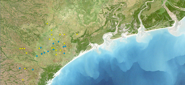
The yellow and blue dots on this map are the locations of Wattled Cranes identified during aerial surveys in Mozambique in 2008-09. These data help ICF researchers estimate population sizes and also can be used to analyze the habitats used by cranes. The varying colors on the map correspond with different types of vegetation and land cover, which means that researchers can identify target areas for crane conservation.
By Dorn Moore, Spatial Analyst
This summer, ICF received an in-kind donation from the ESRI Conservation Program of over $9,500 that allows us to maintain our GIS (Geographic Information System) software and provides technical support when we need it most. ICF received its first ESRI Conservation Program grant in 1995 and has maintained a strong relationship with the grant program ever since. ESRI’s ArcGIS software is currently used by ICF staff in China, India, Vietnam, South Africa, Zambia, and the United States in California, Texas, and Wisconsin. This software helps us analyze migration routes, nesting and wintering areas, and learn more about the habitats and landscapes where we find cranes. We also use GIS software to help anticipate the impacts of management decisions and climate change on cranes and people.

In July, Griffin Shanungu, ICF’s Zambia Program Coordinator, and I attended the Society for Conservation GIS (SCGIS) annual meeting in Pacific Grove, California. Griffin received a SCGIS scholarship to attend extensive GIS training, as well as both the SCGIS meeting and the ESRI International User Conference (read more about Griffin’s research in the August issue of The ICF Bugle). Although ICF has a small number of staff, in the Conservation GIS world, ICF is placed in the same company as The Nature Conservancy, Audubon, and the Wildlife Conservation Society. While at the conference, we worked with other conservation GIS professionals from around the world to help find ways to use spatial technology to advance conservation and were able to provide insight from ICF’s over 19 years of using GIS.
Like many technologies, the use of GIS software is getting easier for regular users. ICF is exploring opportunities to enable the use of GIS to tell engaging stories about the places in the world where cranes are threatened or thrive (for an example, see our Travels with Archie story map). We are also building the foundation for ICF’s staff around the world to easily collaborate and coordinate research using spatial tools.